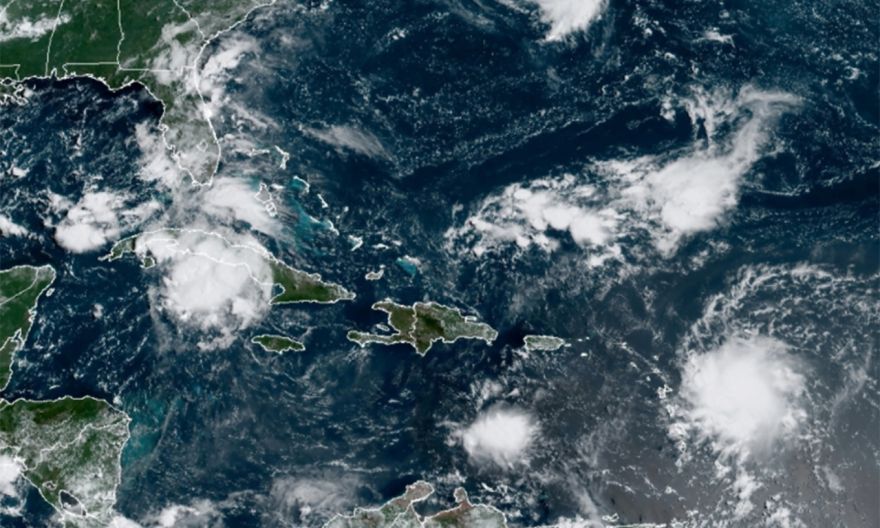
Tropical storm Grace threatens Haiti, churns across Caribbean

NEW YORK (NYTIMES) – Tropical Storm Grace churned in the Caribbean on Sunday (Aug 15), prompting tropical storm warnings for Puerto Rico, the US Virgin Islands and other parts of the Caribbean, and was expected to bring heavy rain and potential mudslides to Haiti, which was hit by a 7.2-magnitude earthquake Saturday, the National Hurricane Centre said.
The storm was moving west-north-west at 16 mph (26kmh) with maximum sustained winds of 40mph, the centre said in an advisory at 2pm Sunday, adding that Grace was about 145 miles (233km) south-southwest of San Juan, Puerto Rico. The centre said Grace could strengthen over the next day, before weakening Monday or Tuesday.
Parts of the Dominican Republic were also under a tropical storm warning or a tropical storm watch, meaning tropical storm conditions were possible within 48 hours.
A tropical storm watch continued for the entire coast of Haiti.
The storm was expected to strengthen as it moved toward the island of Hispaniola, and then reach or pass near earthquake-battered Haiti on Monday.
Parts of the Virgin Islands, the Leeward Islands, Puerto Rico and the Dominican Republic could expect 3 to 6 inches (76mm to 152mm) of rain, the centre said, along with flash flooding. The storm was expected to dump rain on Florida, Cuba and the Bahamas next week.
The storm began to strengthen as a powerful 7.2-magnitude earthquake rocked Haiti on Saturday morning.
Over Haiti, the storm could dump 4 to 8 inches of rain, with isolated totals up to 15 inches, the centre said, adding that heavy rainfall could lead to flooding and potential mudslides Monday and into Tuesday.
Mr Robbie Berg, a hurricane specialist at the centre, previously said the earthquake could increase the chance of mudslides.
“It could have shifted some of the ground and soil which could make mudslides more common,” he said.
One video from Les Cayes, Haiti, showed residents, fearing tsunami warnings triggered by the quake, fleeing a surge of seawater flooding a street. The US Tsunami Warning Centre had reported a tsunami threat for some coasts.
Grace is the seventh named storm of the 2021 Atlantic hurricane season, following several days of floods and power outages unleashed last week by Fred, the sixth named storm of the season. Fred dissipated Saturday, but its remnants redeveloped into a tropical storm Sunday as it approached the northern Gulf Coast, the centre said.
The links between hurricanes and climate change are becoming more apparent. A warming planet can expect to see stronger hurricanes over time, and a higher incidence of the most powerful storms – though the overall number of storms could drop, because factors like stronger wind shear could keep weaker storms from forming.
Hurricanes are also becoming wetter because of more water vapor in the warmer atmosphere; scientists have suggested storms like Hurricane Harvey in 2017 produced far more rain than they would have without the human effects on climate. Also, rising sea levels are contributing to higher storm surge – the most destructive element of tropical cyclones.
A major UN climate report released in August warned that nations have delayed curbing their fossil-fuel emissions for so long that they can no longer stop global warming from intensifying over the next 30 years, leading to more frequent life-threatening heat waves and severe droughts.
Tropical cyclones have likely become more intense over the past 40 years, the report said, a shift that cannot be explained by natural variability alone.
Ana became the first named storm of the season May 23, making this the seventh year in a row that a named storm developed in the Atlantic before the official start of the season June 1.
In May, scientists with the National Oceanic and Atmospheric Administration forecast that there would be 13 to 20 named storms this year, six to 10 of which would be hurricanes, and three to five major hurricanes of Category 3 or higher in the Atlantic.
In early August, in a midseason update to the forecast, they continued to warn that this year’s hurricane season would be an above average one, suggesting a busy end to the season.
Mr Matthew Rosencrans of the NOAA said that an updated forecast suggested that there would be 15 to 21 named storms, including seven to 10 hurricanes, by the end of the season Nov 30.
Last year, there were 30 named storms, including six major hurricanes, forcing meteorologists to exhaust the alphabet for the second time and move to using Greek letters.
It was the highest number of storms on record, surpassing the 28 from 2005, and included the second-highest number of hurricanes on record.


